From Reality 3D to Digital 2D to Virtual 3D
The air is thick. The sun has yet to rise. A peacock calls in the distance. You can barely see the tell. We wait in the dark for dawn to break and then we take off…
This sounds like the beginning of an epic adventure through the wild unknown. It’s not. This is not a tale of some crazy Tomb Raider/Librarian/Indiana Jones. This story won’t involve the adrenaline rush of running from a boulder, but in a way, it has its own beauty and excitement to it. Every morning, I get a slight rush of adrenaline when I nearly fall off the tell to get the perfect shot, all to create a virtual 3D model of what we dig every day.
Worth it?
…Yes.
Why?
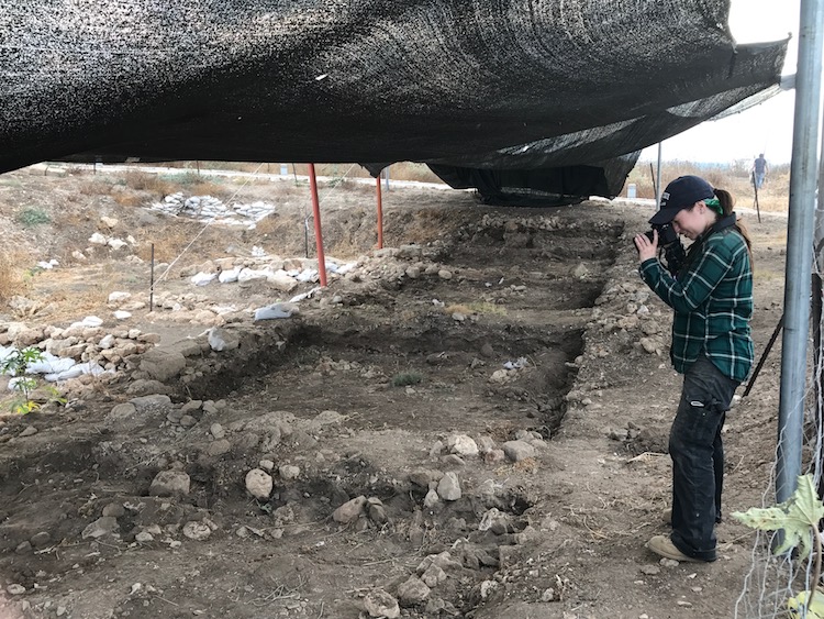
Because this is a really interesting, fairly new technique that has amazing potential for the future of archaeology. At present, many sites use 3D models to record excavation units. It can be used to model most everything from a small vessel to a full site like Akko. On this excavation, this technique is most often used to model the five by five meter squares we excavate every day. Every morning, a few individuals ride out to the tell before sunrise and the rest of the team to photograph the active squares of the excavation. And then we wait. We wait for dawn. We wait for the sun to rise just enough where it is not shinning yet, but it is light enough that the camera can detect features and colors of the site. And then we go into the field and start the process of making a 3D model.
To create a model, we first collect the data (take the photos). We essentially walk around the square 360 degrees, taking photos at eyelevel every couple of steps. Then we round the square again, this time taking a series of overhead shots. The reason for this is to get as full a picture as possible so that when we feed the 40 or 50 photos into a program, it can produce a detailed 3-dimensional model of the square. In short, we are looking at an object in reality, capturing it in a 2D digital image, and then reproducing that image as a 3D model in virtual space.
Being able to create virtual 3-dimesional models is cool enough, but what is really interesting about this process is that there are so many things that can be done with this model. On this project, the 3D models are usually used to create the blueprint from which we draw our plans, write our notes, and record what happens in the square. But there is the potential to do so much more with these models! Because we photograph all of the active squares every day, we can layer these models over one another and create a sort of time lapse of the square. Essentially we are able to track the changes and advance of the excavation over the entire season, seeing the first day and the last day of excavation in one 3-dimensional digital space, long after the soil in the physical space has been carried and sifted away. Looking forward in archaeology, this is a major advance in record keeping that the current generation of archaeologists could have benefited from if their predecessors had had the technology (especially on this dig).
Some sites are even going one step further, using these 3D models to create a virtual reality. Using gaming software and very talented artists, archaeologist can create what is termed a 4D space. They use the 3D model as a base to then recreate what they think the site would have looked like at a given time period. This has a lot of potential for promoting public outreach and understanding. By creating a visual world, the public can understand what we are excavating and bring our world of rubble and dirt closer to the reality it once was.